
October 2, 2022
Arrival
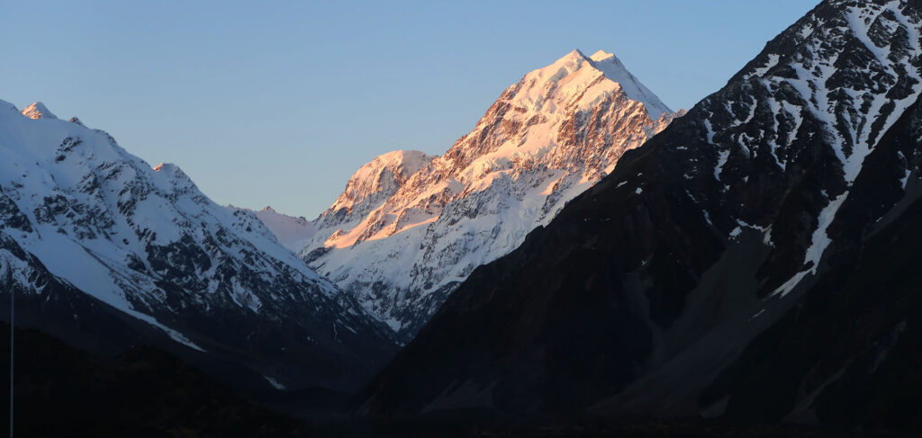
I drove towards Mount Cook Village on a breathtaking, sunny day in early October. For nearly 20 miles, Aoraki/Mt Cook loomed over the landscape as I continued along the shores of Lake Pukaki. At one point I stopped to soak in the views. Not a trace of snow remained along the lakeshore and in the valleys. But permanent glaciers covered Mt Cook.
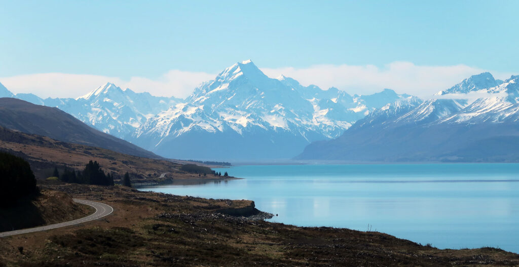
The towering walls of the Southern Alps grew as I reached Mt Cook Village. These rugged peaks run the length of the South Island. They formed via plate tectonics. As the Indo/Australian and Pacific Plates converge, the mountains get pushed higher, presently by 7 mm per year. And Aoraki/Mt Cook stands as the tallest peak both in the Southern Alps and in New Zealand overall.
I parked in one of the large, dirt lots near the trailhead for the Hooker Valley Track. Camper vans were setting up shop nearby. In the late afternoon, on an early spring day, the trailhead didn’t seem especially crowded.
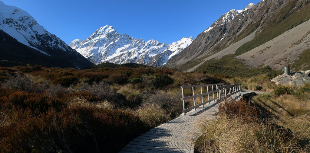
The Hooker Valley Track
I began my hike along the stunning (and super popular) Hooker Valley Track. The trail rises roughly 300 vertical feet (100 meters) in 3.3 miles (5.3 km). The eponymous national park maintains the trail to a high standard, typical of signature hikes in popular parks. You don’t need to be a pro athlete or even an avid hiker to enjoy this one.
Although the trail never gains much altitude, you are surrounded by towering peaks and an ever-evolving view. Aoraki looms straight ahead, a near-constant on the journey. But the rugged slopes of Mt Sefton look equally impressive. In late spring, on a warm afternoon, I saw more than one instance where this peak shed snow and ice, en masse. I would hear a low rumbling sound, like an aircraft, and look to see white smoke and debris raining down from Sefton’s numerous icefalls and seracs.
Glaciation, and the ‘Roaring 40s’
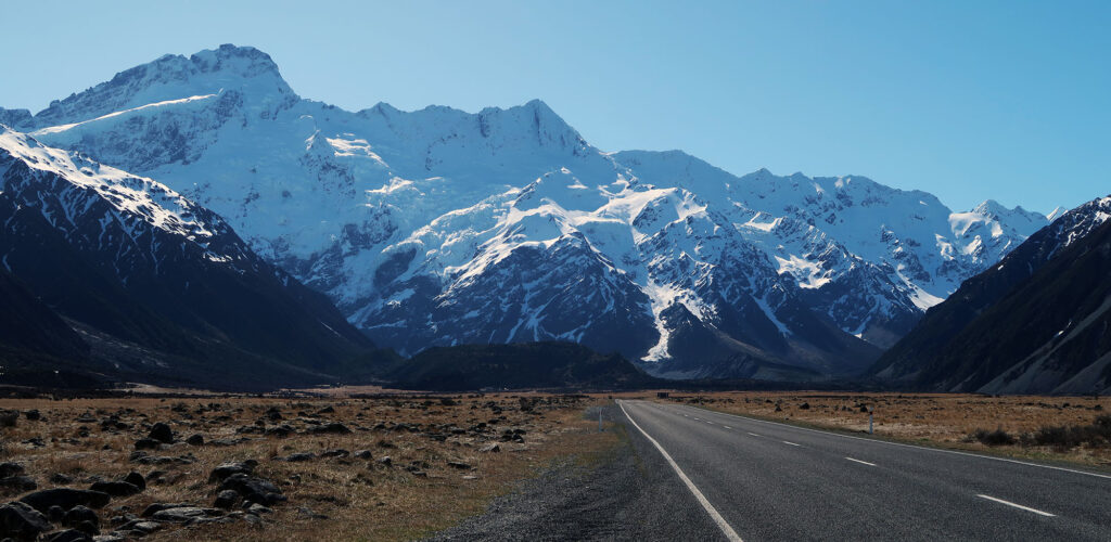
The Southern Alps rise from near-sea-level to altitudes in excess of 10,000 feet. And they do it in under 20 miles from coast to summit! This rivals almost any landscape in the Cascades or Coastal Ranges of British Columbia. And like in those ranges, the tallest peaks sport thick, dynamic, breathtaking glaciers. Aoraki/Mt Cook itself rises in excess of 12,000′.
These mountains present the first major obstacle to prevailing westerly winds off the Tasman Sea. The dense, moist air hits the coast of the South Island and rises up the western flanks of these peaks. Along the way it cools and dumps precipitation, to the tune of 400 inches a year. These strong winds have had no major land obstacles since Tierra del Fuego, half a world away, and thus have earned the latitude the name “the roaring 40s“. Apparently, the “furious 50s” are even worse. As are, in turn, the “screaming 60s”. The southern hemisphere seems rather angry.
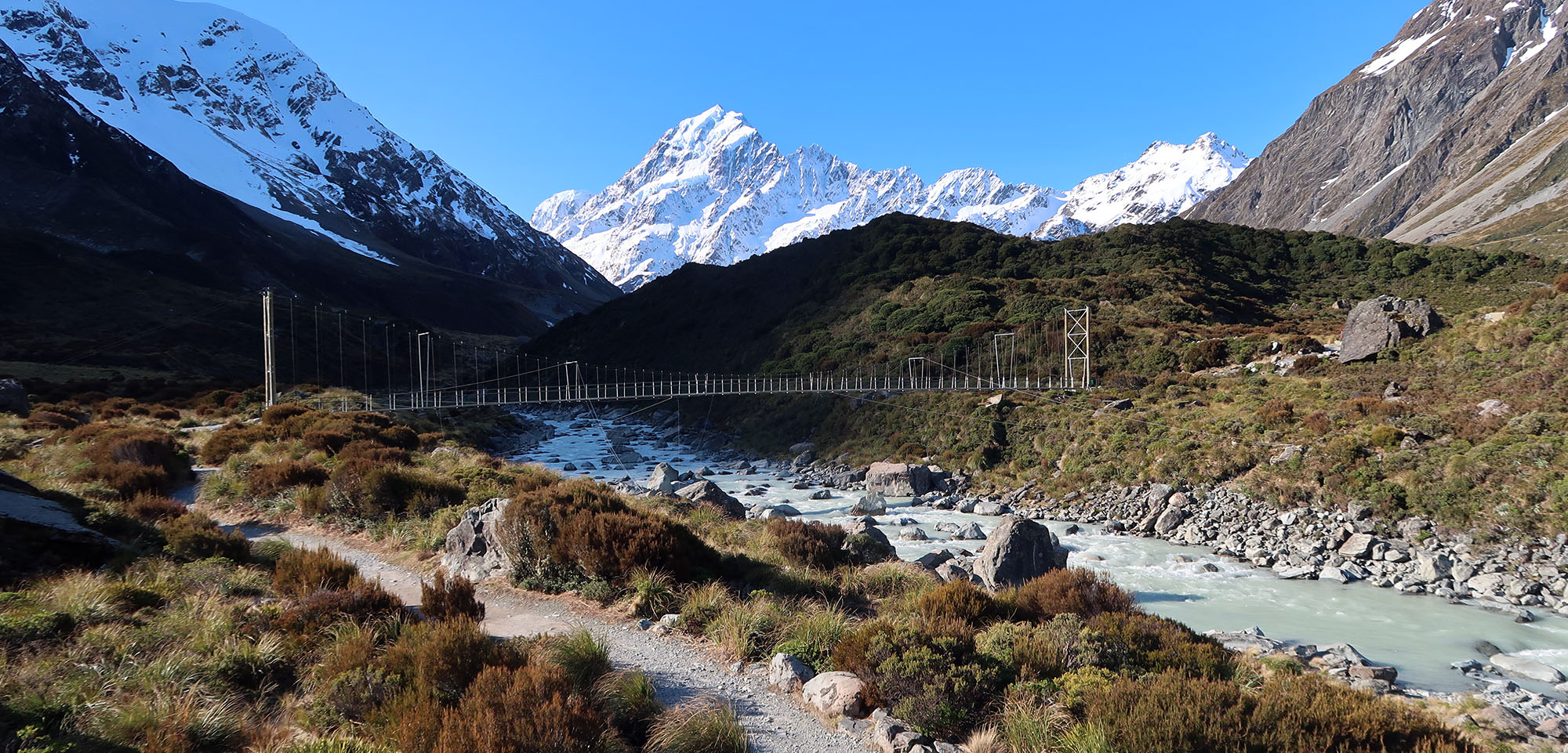
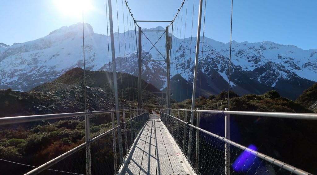
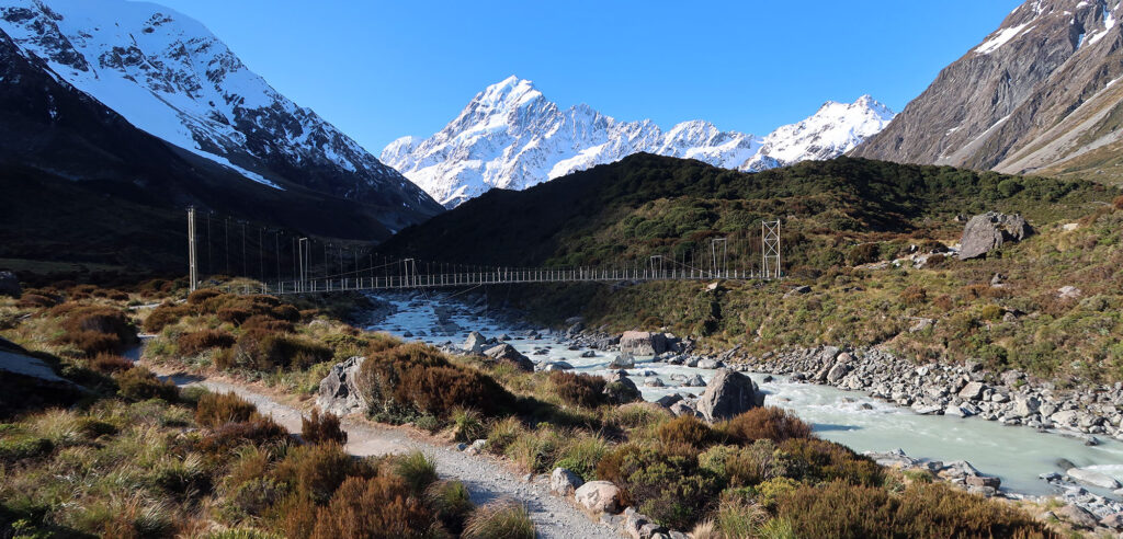
Three bridges along the Hooker Valley Track
Three major suspension bridges break up this hike toward Hooker Lake. The middle bridge closes down in high winds, apparently, due to structural issues. All three spans take you back and forth over the Hooker River, a broad torrent of glacier meltwater from the lake. They appear quite charismatic against the mountains and river.
The trail features gravel paving, well-built wooden steps, and even a bathroom facility near the halfway point. This track was designed to handle crowds of day hikers understandably enthralled by Mt Cook National Park’s grandeur.
Aoraki
Mt Cook takes its name from Captain James Cook, who made three epic voyages around the globe. While Abel Tasman ‘discovered’ New Zealand, Cook visited on all three voyages and spent time charting its coastlines. Two of the United States’ five space shuttles are named after his ships (Endeavour and Discovery).
Of course, the Maori arrived fully 300 years before Tasman laid eyes on the archipelago. They had several names for the South Island, among them Te Waka a Māui (Maui’s Canoe) and Te Waka o Aoraki (Aoraki’s canoe). This final name alludes to a legend of Aoraki and his brothers sailing the world, before being turned to stone and becoming the South Island of New Zealand. Thus Aoraki, the tallest peak in New Zealand, represents their petrified ancestor.
The mountain reverted to a combination of both names, officially, in 1998. This came as part of a broader acknowledgment of Maori heritage and culture in New Zealand.
Hooker Lake
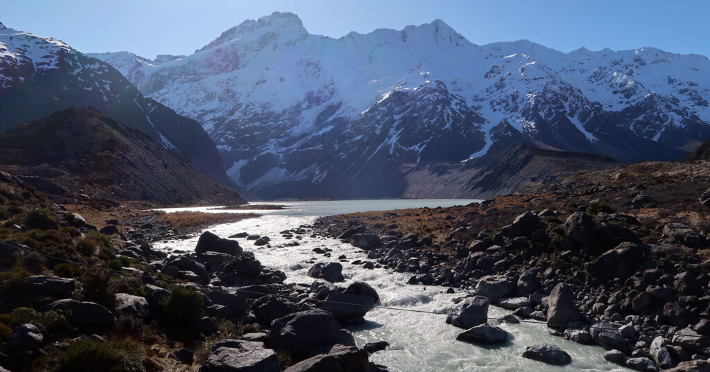
The Hooker Valley Track takes you past two large, proglacial lakes. These lakes formed as former glaciers melted and receded, leaving behind a damn of rock and debris (a glacial moraine). The upper lake, Hooker Lake, forms the terminus of the hike.
You can see icebergs floating in Hooker Lake in spring. Though when I visited, none of these were especially nearby. Aoraki, as always, lords over the seen, now reflected in the lake.

A series of alpine huts sit above the gentle Hooker Valley, including two en route to Mt Cook’s rugged summit. The mountain went unclimbed until 1894 when New Zealander Tom Fyfe made the first successful summit.
Half a century later, the mountain captured the attention and interest of a young Edmund Hillary. Hillary would go on to join a British Expedition to Mount Everest. And together with Sherpa Tenzing Norgay, he made the first successful summit of Everest, just days before Queen Elizabeth II’s Coronation. Today the Hermitage Hotel in Mt Cook Village hosts a museum dedicated to one of New Zealand’s most illustrious citizens.