
July 21, 2017, Adirondak Loj
Out of my comfort zone
My very first Adirondack 46er adventure began around 7:00 am, in the parking lot at Heart Lake. It would be a weekend of many firsts. Most obviously, it was my first pair of high peaks: Skylight and Marcy. But beyond that, it would be my first time backpacking and backcountry camping. In fact, it would be my first time pitching a tent in the woods. I’d been “car camping” exactly once before.
All that said, I didn’t consider myself that unprepared. I’d spent hours obsessing over every detail on the internet, building a giant checklist of everything I needed. The wonderful folks at REI had walked me through everything from sleeping systems to water filtration to cooking gear. I spent multiple Saturdays grabbing the Hudson Line train to Breakneck Ridge for some practice hikes. I strapped on all 30 lbs of my filled pack, which looked quite ridiculous next to all the other day hikers. Then I’d march up and down the mountain to condition myself. I had even gone to Prospect Park, near my home in Brooklyn, to practice setting up my tent on a grassy lawn.
But nevertheless, I was crazy nervous. What about the bears? What if I got lost in the wilderness? My stove broke? My sleeping bag got wet? What if I forgot my bug spray? Or my tent stakes? How strong is the wind at night? What kind of temperatures should I be expecting? With every question I asked the internet, five more problems arose. Black flies? What are those? Do they hurt?! Will the parking lot be filled by 3:00 am?! Just how crowded are the high peaks these days?
Arrival
Even from the parking lot, one big fear was assuaged. The trailhead parking was nowhere near jam-packed. In fact, it was mostly empty, despite the gorgeous weather. The same would be true of the trails and campsites throughout the weekend. This, I would later learn was for a few reasons. First and foremost, it was a non-holiday weekend, and it was not a Saturday. But I think part of this came down to the Lake Placid Ironman being held that weekend. The hotel rooms in town were full (of non-hikers) and many would-be hikers were busy swimming, biking, and running in the valleys.

Hitting the trail
After an embarrassingly long time spent strapping into my boots and finalizing my pack, I headed towards the trailhead. Just before entering the woods, a park ranger stopped me and performed a rather abrupt interrogation. Was I camping overnight? Yes. Did I have a bear canister? Yes. What color was it? Black. It was a pop quiz and I passed. His suspicions quickly faded. He smiled and asked the route I was taking and told me to have a wonderful time. Let this be a lesson to anyone heading into the high peaks overnight. If you don’t carry a bear canister the rangers will find you!
I set off south, along the Van Hoevenberg trail, somewhat pejoratively nicknamed the “highway to Marcy.” This trail gains the summit in 7 miles, which many folks do as a somewhat aggressive day trip. Even with a light pack, 14 miles is quite a long day trip. That said, there are no especially steep sections, lots of helpful “bog bridging” over wet spots, and despite heavy traffic, the sections I’ve hiked are not especially eroded—a big problem in the Adirondacks. Hence the “highway” nickname.

Marcy Dam to Avalanche Pass
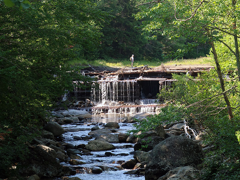
Soon enough, I reached Marcy Dam, the first big milestone of the hike. My goals this weekend were a bit more expansive than simply summiting New York’s highest peak. I wanted to rope in Skylight, another high peak just south of (and a bit more remote than) Marcy. And I wanted to camp somewhat close to the summit (not an option along the Van Hoevenberg trail). And so, upon reaching Marcy Dam, 2.3 miles in, I headed due south on the trail to Avalanche Pass.
The first few miles of this journey were among the easiest of the whole trip. Flat or slightly uphill. Soft, compacted dirt beneath my feet. Wide-open old-growth forests with bits of sunshine peeking through the shady canopy. I mention this because you should definitely NOT assume most of your miles will be anything like this.

Avalanche Pass
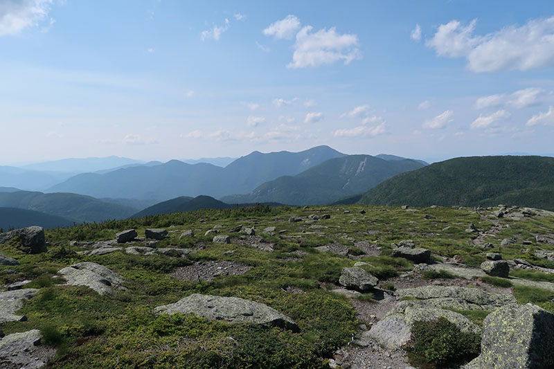
The most efficient high peak day-hikes from Heart Lake (Marcy, Algonquin, Colden, Phelps) don’t involve Avalanche Pass and Lake. And that’s a terrible shame because the Avalanche route is among the most gorgeous treks in the Adirondacks. The trail rises at a moderate pace into Avalanche Pass, 3000’ above sea level and 1000’ above the trailhead. From there it squeezes between some massive, moss-covered boulders (glacial erratics?).
There’s some emergency avalanche gear placed here for rescue efforts in winter. And the first of Mount Colden’s many massive “slides” comes into view through the trees. This particular slide is 800 linear feet of exposed bedrock. At some point, the soil and vegetation sitting on top came loose and slid, wholesale, down the mountain. Slides are basically the remnants of a dirt/rock/tree avalanche.
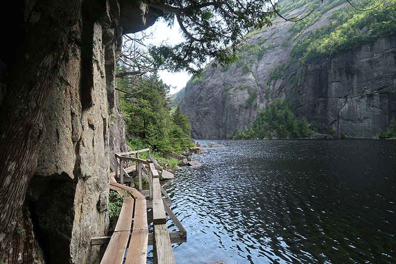
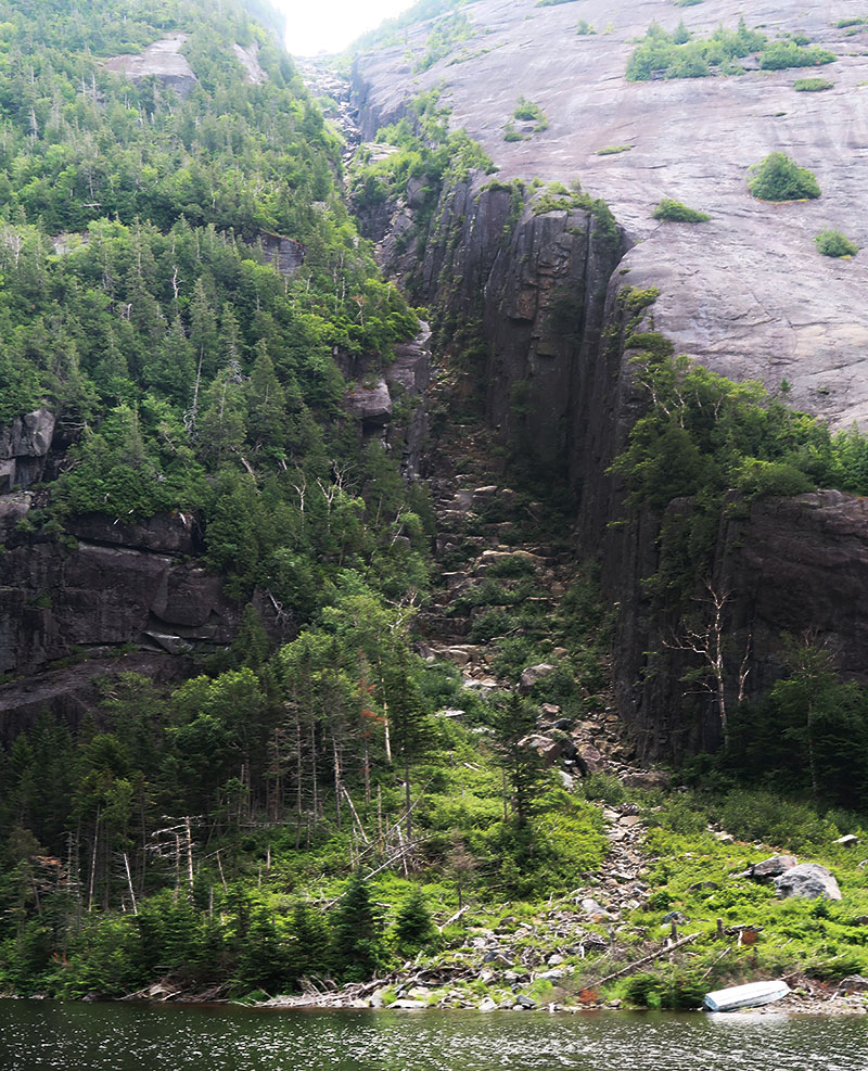
After avalanche pass you descend about 200 vertical feet to Avalanche Lake. This large but narrow lake sits sandwiched between the base of Mount Colden and Avalanche Mountain. Steep cliffs rise up from either side. While I’m not a geologist, I’d say this was a textbook case of a heavily glacier-influenced landscape. Whatever the case it’s gorgeous.
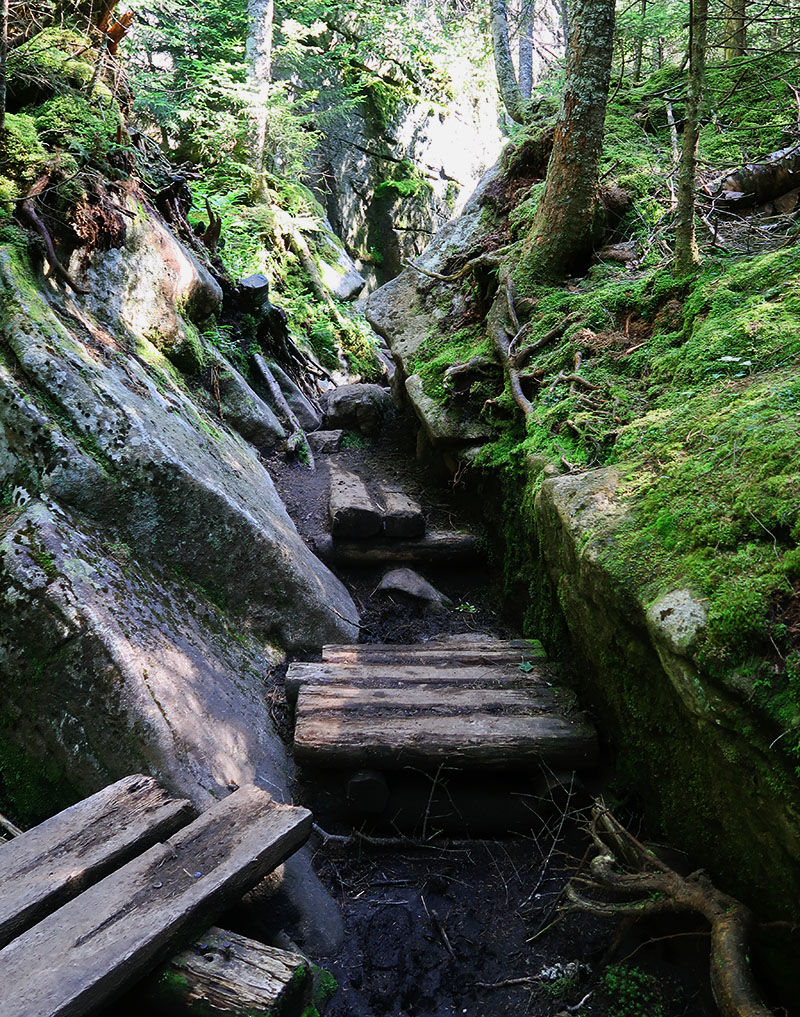
After three miles of effortlessly tromping through the woods, the next mile took … quite a bit more effort. The trail along Avalanche Lake is slow going, but tons of fun. You work your way along the lake’s shoreline and beneath massive cliffs, scrambling over large boulders. There are even sections where the cliffs and lakeshore meet, leaving no room for foot traffic. The trail crews have improved matters, to an extent. The route sports numerous ladders, boardwalks, and a few bridges anchored to the cliff walls known as “hitch-up Matildas”.
Despite these improvements, there are still plenty of places where you may feel (delightfully) stretched to your athletic limits. At one point I reached a void between the trail and the next boardwalk. My 5’5” frame was insufficient to span the gap without jumping. Over open water. Wearing my food and camping equipment on my back. That was fun.


Lake Colden
The whole avalanche lake scrambling experience lasts about half a mile, and what an incredibly scenic half-mile it is! This route would make an excellent lower-altitude day hike. It also leads to some excellent remote campsites along Lake Colden.
After Avalanche Lake, I continued along the southeastern side of Lake Colden. Lake Colden seemed a bit less exciting than Avalanche Lake in every way. Wooded hillsides replaced massive cliffs. Giant boulders gave way to smaller, more manageable, but still annoying boulders. And a big fancy ranger outpost sat right across the lake. While comforting to see, this spoiled the thrilling illusion of untouched wilderness. All that said, Lake Colden is still gorgeous. And on future trips, traveling along its northwestern shores, I was blown away by the gorgeous views of Mount Colden. Definitely a great place to camp.
Here I crossed paths with a small group of older men and women. Aside from spotting a couple tents near Marcy Dam, this was the first human encounter since the parking lot. Not bad for a bluebird Friday in July!

The Opalescent River to Feldspar Lean-to
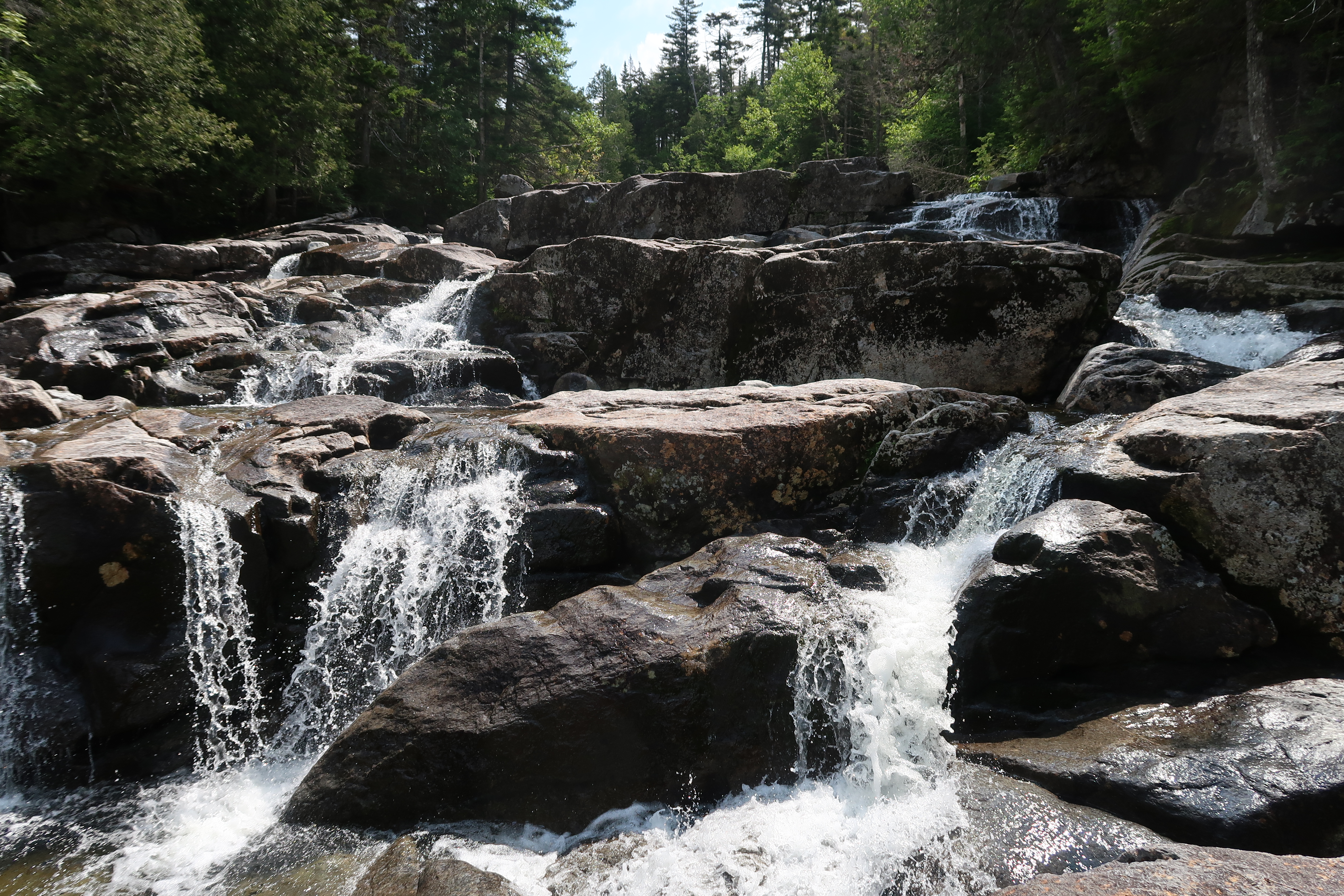
Having reached the far end of Lake Colden, I now began the ascent towards Marcy, Skylight and my campsite (not in that order at all). I followed the trail towards Marcy along the Opalescent River, which is a delightful name for a delightful mountain brook! This was a very pleasant, mild ascent, rising about 500 vertical feet in a bit over a mile. The route stuck close to the rushing waters of the Opalescent the whole way.

Passing the Uphill Lean-to, I then turned left and continued along the Opalescent to the Feldspar lean-to, where I would set up camp. The trail to Marcy makes a sharp right uphill prior to Feldspar brook. But the Feldspar Lean-to actually lies along a different trail, reached by staying straight along the Opalescent. From the main trail, a cute bridge crosses the Opalescent to the lean-to and its (rather nice) campsites.
I bypassed the (empty) lean-to and instead set up my tent in one of several solid campsites. It was still peak mosquito season and tents are not allowed in lean-tos. I found no other campers when I arrived. But another solo backpacker would show up by nightfall and pitch his tent in a nearby clearing. I was very thankful for this company within earshot (because bears).

Setting up camp on the slopes of Marcy and Skylight
You can technically camp almost anywhere in the High Peaks Wilderness. Any patch of woods below 3500’ and ample distance from trails and water sources works. But I strongly prefer the marked campsites, for several important reasons:
- They tend to sit closer to water and trails than the rules technically allow.
- They almost always feature pit privies and outhouses. While somewhat smelly, these options are way more convenient than digging a cathole.
- They tend to exist in dry, flat areas surrounded by trees. This often means fewer bugs than a lot of other places you could pitch camp.
The Feldspar site was particularly nice. My tent site featured a soft bed of pine needles. Thick, wind-shielding conifer trees surrounded the area. The nearby rushing brook provided some ambient noise and ample fresh water. And crossing the log bridge to the main trail was just plain fun every time.

A sneaky visitor
I set up my tent and sleeping system and popped open my bear canister to replenish snacks and have some lunch. I walked down to the Opalescent to purify some water and made the rookie mistake of leaving my bear canister wide open. When I came back to camp I saw a small, furry creature slinking surreptitiously towards the canister. It noticed me, startled, froze gazing up at me for a moment, and then darted in a flashback into the woods. Its behavior was so absurdly weasel-like, I came to the conclusion that it must have been, well, a weasel. In fact, the internet suggests I was not too far off … it most closely resembled a marten.
And this brings me to an important point about bear canisters: they’re not just for bears! There are dozens of woodland creatures that would love to steal your food, and while hanging a bag from a tree prevents a lot of them, the bear canister is just a more sure bet. Is it kind of heavy? For sure. But 2.5 lbs is really not a game-changer for a weekend excursion. On short trips like this one, I’ve taken the habit of putting my cooking system and toiletries in there too, even during the daytime, and with that approach, it doesn’t even take up too much extra space in my 50-liter pack.
Lake Tear of the Clouds
My original plan for the day ended at Feldspar Lean-to. But I began my hike earlier than originally planned (out of fear of no parking—thanks internet). And it was now only 1 pm. With ample energy and daylight left, I decided to summit Skylight and enjoy some afternoon views. I backtracked down to Feldspar Brook and then headed up the trail towards Marcy.
Since Lake Colden, I’d been consciously traveling along trails that allow you to trace the source of the Hudson, Lewis-and-Clark-Style, from the headwaters of the Hudson River proper at Upper Works, along Calamity Brook, to the Flowed Lands, Lake Colden, the Opalescent River, and Feldspar Brook until you reach … Lake Tear of the Clouds!
Sort of. The Hudson officially ends at Henderson Lake, way back at Upper Works. But yes, Tear of the Clouds does eventually flow into the Hudson, and at roughly 4300’ above sea level, it’s therefore the highest source of the Hudson! Again, sort of. There are probably some small brooks that start higher up. But you know what, it’s a poetic-sounding place, on the slopes of Mount Marcy, and for many years I’d been dying to visit.

It’s not a very big lake, in actuality a small tarn that looks more like a marshy pond than anything else. But it’s at roughly the same height as Vermont’s tallest peak, and surrounded by dramatic views of the high peaks, and in the mid-afternoon sun, with the wind hitting the water’s surface, I thought it was beautiful.
T.R., Mt Marcy and Lake Tear of the Clouds
Lake Tear of the Clouds also plays a minor role in American history. Vice President Teddy Roosevelt was hiking down from Mt Marcy, when a group of men met him near this small tarn, to deliver the news that President William McKinley would soon die from his assassination attempt. Thus it is this auspicious spot where Roosevelt learned he was soon to be president. Why the Vice President had decided to go for a long hike after an (eventually successful) attempt on the President’s life seems beyond me. Maybe for dramatic effect? But at any rate, it adds yet another maybe-entirely-true footnote to the illustrious tale of this somewhat beautiful, sort-of lake that is kind of the source of the Hudson River, high on the slopes of New York’s definitely-tallest peak.

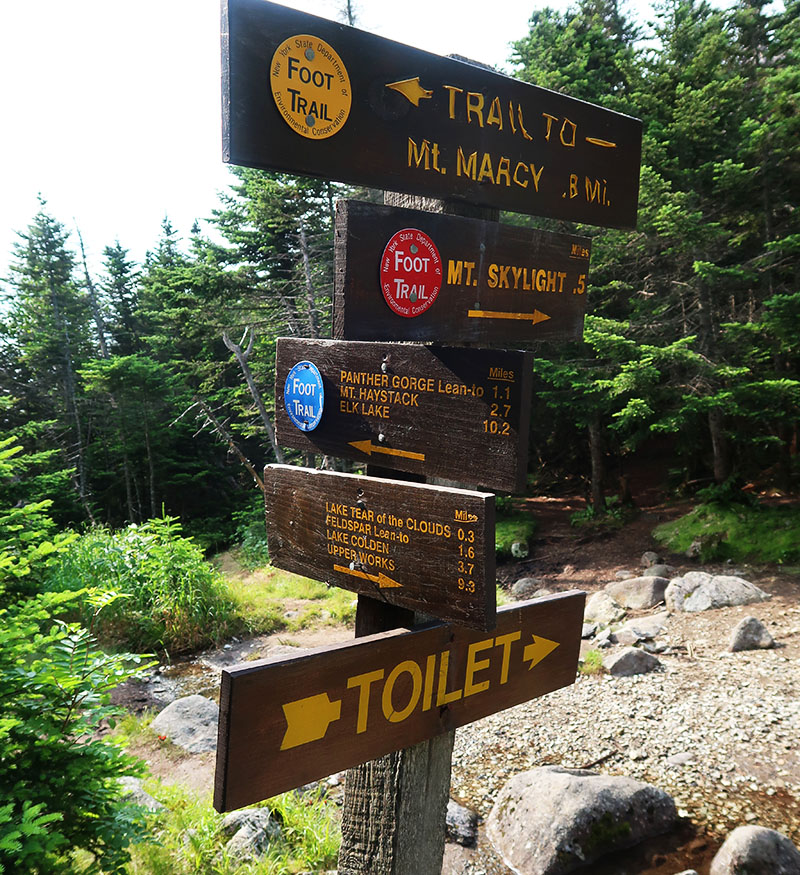
Tear of the Clouds sits in a col between Marcy and Skylight, two of the tallest peaks in the Empire State. The trail I approached it on meets the routes to their summits at a point known as the “four corners,” where there’s a final fourth trail down into Panther Gorge and towards Elk Lake to the south. At the four corners, you’ll find a somewhat amusing trail sign that lists places you can travel to in order of importance (depending on the state of your bladder).
Ascending Skylight
From the four corners at Lake Tear of the Clouds to the summit of Skylight is a 630’ vertical rise over roughly a half mile—among the steeper portions of my first high peaks adventure. The journey is almost entirely through thick, conifer (boreal) forest, and the trail can feel like a narrow, linear sweatbox in the mid-afternoon sun. Down in that evergreen trench, the air is stagnant and full of bugs.
Higher altitude, in theory, sounds cool and refreshing, but on a July day of a particularly wet summer, I was now acutely aware of the fact that higher altitude forests take longer to properly dry out. Thus the trail felt like a humid, sun-baked, swampy mess. I climbed higher and higher, working up quite a sweat. Eventually, near tree-line, I reached the first of many “arctic/alpine” warning signs, an Adirondack version of “Almost there!—Now please don’t step on the plants!”

An alpine meadow atop Skylight (#1)
As I broke above treeline, the swampy, bug-infested, inclined Siberian swamp gave way to crisp, windy alpine tundra. Yay microclimates. The summit of Skylight was a broad, rounded alpine meadow, devoid of trees and with views in all directions. I could see a few tiny people atop nearby Marcy, but other than that, I felt alone in a vast wilderness. The afternoon sun was still somewhat high in the sky, but low enough to pass through thicker atmosphere, giving everything a somewhat golden quality. A green, golden summit, amidst a blue sky with small, puffy white clouds—what a fantastic introduction to the high peaks!

I sat for a bit, feeling the refreshing wind in my face, and taking note of Skylight’s two massive summit cairns. You’re supposed to bring a rock to the summit and place it on the cairn for good luck. I took a rather small one down at the four corners, and placed it on the far cairn. Maybe that was sufficient just to prevent bad luck? Not entirely clear what the Gods might think.
The strong winds felt fantastic, but compelled me to put on my rain shell for warmth. As a big fan of fall and winter weather, getting this experience on a hot July day was just delightful: like standing in front of a massive air conditioning unit. No wonder so many rich people summered in the Adirondacks pre-A/C and jet planes.

Satisfied with my brief summit experience I descended the peak, knowing that even if I were eaten by bears in the wee hours of the night, I’d at least die having summited one high peak. As I reached treeline, I was struck at how suddenly all the swampy bug-infested awfulness of the boreal forest came right on back. Luckily this time I was descending, which took considerably less exertion.
Gray (#2)
Back at the four corners, I retraced my steps passed Lake Tear of the Clouds. I then spotted the small cairn that marked the herd-path to Gray Peak. Gray is a minor, trail-less peak near Marcy and Skylight of little prominence. Despite all this, Gray makes the cut as a high peak—among the 10 tallest, in fact. There was still plenty of daylight. That said, the idea of a peak devoid of trail markers, deep in the wilderness made me nervous. But I decided to give it a shot. It seemed pretty dumb to come all this way and pass up another high peak that only cost half a mile and 500 vertical feet. And Gray sits nowhere near any peaks besides Marcy and Skylight.
Halfway along this herd path, I reached a rather sketchy rock face that required a bit of jumping and a whole lot of scrambling. I thought to myself about the DEC interior outpost, a few miles downhill, and completely out of screaming distance. I thought about how it was somewhere around 6:00 pm and how unlikely it was another hiker would come through here today. But I took a leap of faith (quite literally) and in short order, I had reached my first trail-less peak. A snapped a pic of the first of many brown signs nailed to a tree trunk.

Feeling doubly satisfied with two high peaks down, I descended from the col along the Opalescent River and proceeded back to camp at Feldspar Lean-to. It was now nearing sunset, and the woods were filled with a reddish light. What a great day!
A night in the forest
After briefly chatting with the only other camper at Feldspar, I went back to my tent site and “cooked dinner”. This consisted of a freeze-dried beef stroganoff brought to life via boiling water from my brand new JetBoil. Believe it or not, it tasted pretty great, but that may have just been all the hiking. At any rate, it was better than endless peanuts and Clif bars.
The weird thing was I wasn’t all that hungry. A big mistake I made the first couple of camping trips was to hard-core hike right up until sunset/dinner time. This means going from heavy exertion to digesting food in the span of an hour or so, followed promptly by sleep. My body does not approve of this pattern of behavior. In later trips, I realized I had a far better appetite—and a superior digestive experience—if I gave myself an hour or two to unwind at camp.
There are other bonuses from finishing well before sunset. You can dry out your boots and socks (camp shoes are great for this reason, among others). In fact, you can clean and dry out all sorts of things that may have gotten wet or muddy.
But at any rate, this first night was a prompt transition from hiking to food to bed. I brushed my teeth, stashed my bear canister, and crawled into my tent.
Overnight lows in the Adirondacks
Back home at REI, while perusing an overwhelming array of brand new backpacking equipment, I had asked the sales rep if they had a sleeping bag designed for people who hate really hot, humid weather? Like something rated for 75 Fahrenheit and super breathable. She looked at me quite puzzled. My hometown of Brooklyn might feature many hot, smelly nights like this in mid-summer, but in the Adirondacks a typical July night could easily reach 40 Fahrenheit, even down in the valleys.
Luckily for me, the salesperson at REI steered me to a somewhat lightweight synthetic sleeping bag rated for 34F, and between that, lightweight long underwear, a micro puff vest and a wool cap, I was still pleasantly cold when I awoke the next morning. In fact, it was so cold that getting out of bed to pee was a bit of an exercise in will-power.
Heading above treeline on Marcy
After some oatmeal and hot cocoa, I warmed up enough to start breaking down camp. From first unzipping the tent that morning to hitting the trail was a surprisingly drawn-out 2-hour affair. I’ve gotten substantially faster in recent trips, in part by opting for a no-cook breakfast, but mornings continue to be a somewhat involved process.
Somewhere around 8 am I finally hit the trail, and retraced my steps up Feldspar Brook to Lake Tear of the Clouds, back to the Four Corners, and now onwards up the slopes to New York’s highest summit. Like Skylight, the ascent initially involved a narrow tunnel through thick boreal forest. But after a half mile and 500 vertical feet, this gives way to a beautiful, open ascent along an exposed ridgeline of bare rock.

This final, open ascent was the steepest section I’d hiked thus far and was mostly devoid of switchbacks. Progress was marked by numerous, large cairns with often three or four visible at once up ahead. These provided nice little mini-goals, but also seemed to emphasize how much vertical remained. But after a final 500 feet of vertical, I had arrived at the summit.
A crowded summit on Mount Marcy (#3)
It was somewhere around this point where my new digital camera had died, since I’d accidentally switched it to this weird mode where it videotaped the time between photographs. Sadly I have no more high-quality photographs of this excursion!
My Saturday morning ascent to Marcy along this southern approach had been entirely devoid of human contact right up to the summit. But upon reaching the summit, likely sometime around 10 am, I was suddenly greeted by a half dozen groups of multiple hikers. These folks were mostly day hikers, having started super early that morning back at Heart Lake, ascending light and fast along the Van Hoevenberg trail.
The views from Marcy are quite stunning. I wish I had good pictures, but basically, Colden and Algonquin looked quite on-fleek that morning.
I chatted briefly with the summit steward before beginning my descent, northward, along the Van Hoevenberg trail. While I only traveled along this route for half a mile, I passed more people in this brief descent than on the rest of the 3-day trip combined! So let that be a warning for anyone planning an ascent of Mt Marcy!
I descended off Marcy into the Johns Brook Valley. My plan was to head back to Heart Lake via Klondike Notch.
Haystack (#4)
Having descended from Marcy towards Johns Brook, I came to a point fork in the road where the trail signs advised me that I was within a mile of Mount Haystack. Dare I attempt a fourth high peak? I decided to bite.
I had no intention of summiting New York’s third tallest peak on that gorgeous, sunny Saturday, but I am so thankful I did. The ascent proved steep and involved lots of scrambling. The route involved two craggy sub-peaks en route to Haystack that added substantial vertical. But the majority of the ascent happens along a bare, rocky ridge. And the views were spectacular!
While Marcy was crowded and noisy, even rather early in the day, Haystack was quite quiet and contemplative. Along the ascent I could see a woman trail running a ways ahead of me, and at the summit, there was a man relaxing solo in the shade of a rock ledge, and an older couple that had hiked up the backside from Elk Lake. But other than that, I had this gorgeous, open-air, rocky playground largely to myself.
My first Adirondack “death march”
There were many more hours of hiking that day. I descended the Phelps trail down into Johns Brook Valley, passing many lean-to’s at Slant Rock, Bushnell Falls and onward. This trail was incredibly rocky and eroded, and I was definitely starting to get very tired of negotiating large fieldstones. My first Adirondack high peaks adventure was apparently to include my first death march.
Eventually I reached Johns Brook Lodge, in the heat of mid-afternoon afternoon. I sat briefly at a picnic table in the sun, but was swarmed by insects. Despite my diligent application of picaridin, these little demons had no qualms biting me anywhere my skin was exposed. They were the first (and last) bug bites of the trip. I’m not sure what’s going on at JBL but perhaps many years of visitors have allowed the local insect population to develop picaridin resistance?
The day, unfortunately, would end with an ascent, roughly 1000’ into Klondike Notch, westward towards Heart Lake. My plan was to camp at the Klondike lean-to that night. The trail was directly behind JBL, and luckily far less worn out than the Phelps trail. I was relieved to once more find soft dirt beneath my feet along this relatively painless ascent through the tall forest.
The journey back to Heart Lake
By the time I reached the lean-to it was dark. I set up my tent near the empty lean-to and again made a quick freeze-dried dinner before hitting the sack. The Klondike lean-to sits right alongside the trail, super close to Klondike Brook. And the brook provides lots of great babbling brook white noise to fall asleep to at night.
The next morning I awoke to finish off the last four miles or so to Heart Lake. My original plan was to use the Mr. Van Ski trail to cut back to the Adirondack Loj, but alas this is not a hiking trail in summer and the tall grass that covered it seemed like a great place to pick up tick-borne diseases. Instead, I continued to South Meadow and then walked along the roads to Heart Lake. There were lots of folks car camping in this area and it was fun to see all the elaborate, large tent setups. Quite a contrast to backpacking!
It was before noon when I arrived back at my car and was able to finally remove my hiking boots and change back into fresh, dry cotton clothes. I signed the trail registry, having completed my journey, and then headed into Lake Placid for some high-quality caloric intake. My first High Peaks adventure had come to a successful close, and it was time to rejoin civilization. Marcy, Skylight, Haystack, and Gray peaks were in the books!