
January 25, 2020, Bradley Pond Trailhead
Into the night
The “day” began around 3:30 am, when my alarm when off at the Owl’s Head Lodge in Newcomb New York, smack dab in the center of the Adirondack Park. As a winter day hike, the Santanoni’s would become the single-longest day to date in my 46er adventures.
By 5:30 am I had arrived at the Bradley Pond trailhead, deep in the woods, 10 miles north of town. Even visiting in summer, to tackle the McIntyre Range, this area of the park had felt super isolated. But in the dead of winter (and the dead of night), it felt incredibly remote.
A couple fresh inches of snow had fallen in the prior few hours and I started right off the bat in snowshoes. They wouldn’t come off my feet until I was back at the car, twelve hours later. I clicked on my headlamp and set off towards the Santanonis.

Santanoni has always struck me as a bizarre name for an Adirondack High Peak. Most mountains are named after animals or Native words or prominent geological features. Or mostly just dead white men with English-sounding names. But Santanoni sounds like something that belongs in the Dolomites of Italy rather than northern New York.
In fact, the name is likely an American Indian variation on “Saint Anthony”, which was how French trappers referred to the area. It seems fitting that Anthony is the patron saint of the lost. Hiking through this quiet, remote stretch of woods between the hills, I began to imagine how those early explorers of the region must have felt, many, many miles from their settlements and across a vast ocean from home.
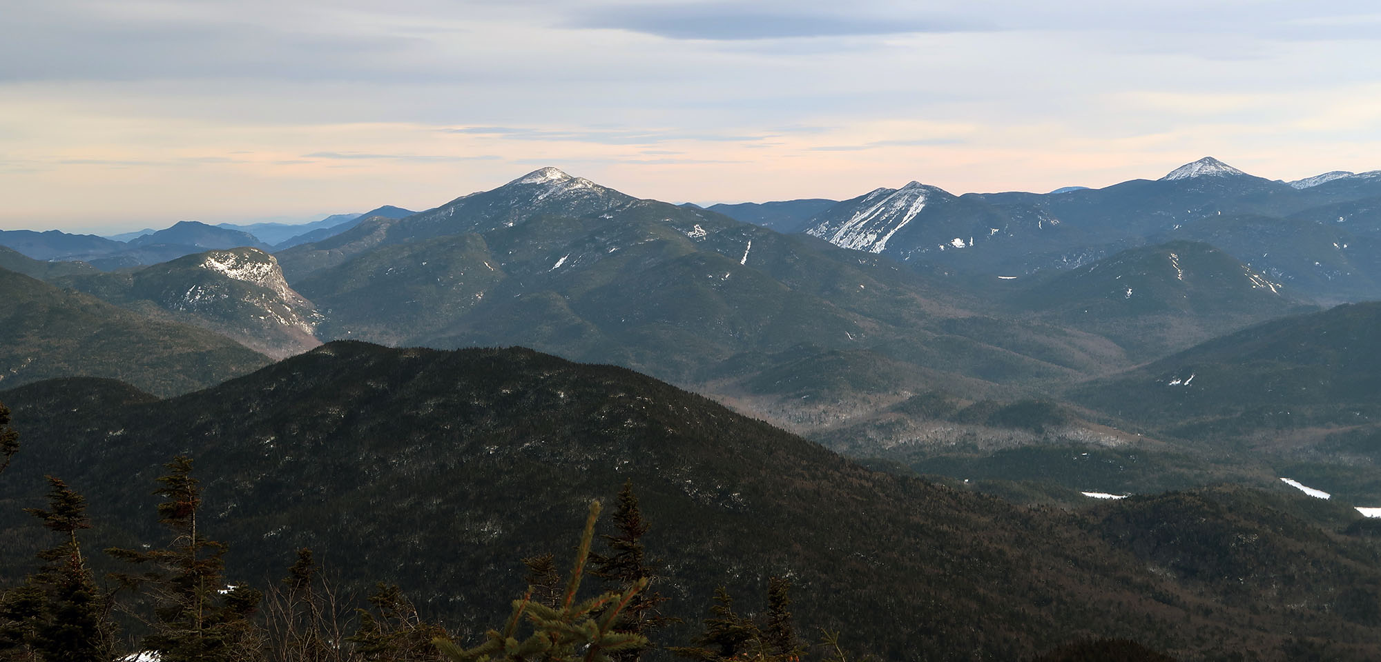
Sunrise on Santanoni Slide
The trial began with a couple of miles along an old logging road. Halfway along this stretch, the roadway has been washed out from a recent large storm. Recent videos suggest this crossing can be tricky after heavy rainfall, but on a frozen day in late January, it was super easy to cross.
Soon the trail left the roadway and began gently ascending into the woods. I gained a small ridge and turned around to see the first direct sunlight forming deep pink and purple light just below the cloudline. The bare hardwoods were silhouetted against this gorgeous backdrop.

I switched off my headlamp and allowed my eyes to adjust to the morning light. The trail continued to climb, and soon Santoni’s large southerly slide came into view. The snowy spillway reflected the morning sunlight, and gave the peak a lot of personality.

Roughly four miles into the day and 1000 vertical feet from the trailhead, I came to the first fork in the road, where the “Santanoni Express” herd path departs from the offiical DEC trail to Bradley Pond lean-to.
The Santanoni Express
I’ve never seen the Santanoni Express marked on an official trail map. The ADK map labels at least one herd path to every High Peak, but as of the 2015 edition, this route was not one of them. Luckily for me, I recently started using the All Trails app, which clearly labels this route as part of a quasi-loop among the three peaks.
The Santanoni Express is a fantastic way to ascend its eponymous peak! The trail proves steep but nothing a seasoned 46er hasn’t experienced before. And it’s got some stunning views of the central high peaks as it ascends.

The trail ascended in spurts over a few ridgelines. The sun rose further in the sky, and Marcy, Algonquin, Colden, and various other peaks soon came into view.

Santanoni (#38)
The trail grew quite steep, and soon gained a major ridgeline that led towards the summit. The top of Santanoni came into view, with deep snow visible between the thin, boreal forest.

I clicked into the heel locks on my snowshoes and began the final push to the summit. The sun was still low enough on the horizon to shine brightly through thin cloud cover, lighting up the central high peaks to the east.

It was now mid-morning, and with one peak in the books, I began the gentle descent along the ridgeline to the north, towards the junctions known as “Times Square” and “Herald Square”.
Couchsachraga (#39)
In short order, I reached a boulder marking the junction. Many folks have remarked on the unremarkably of these intersections. But as a straphanger of 10 years, I appreciated the irony of naming a couple of the most remote places in the state after some of its most crowded.
I took a left and began the descent towards Couchsachraga.
Much ink has been spilt bemoaning the lowliest of official High Peaks. Couchsachraga is remote. At 3,820′ elevation, it’s not a “real” high peak. And with a gross elevation gain of roughly 3,800′ without also bagging Santanoni and Panther, it’s the only high peak whose minimum vertical gain is commensurate with its height above sea level.
All that said, I enjoyed the trek. The descent to the col was relatively harmless (if deep!). And the infamous Couchsachraga bog was helpfully frozen solid and covered in soft snow.

The route to Couch also sported some fine views. The Sewards stood prominently to the West, across a dramatic stretch of low-lying bog. It was neat to see oft-neglected high peaks commanding attention, if only for one short stretch of trail.

The journey took a surprising amount of time, but eventually, I stood atop Couchsachraga, facing its summit sign. The word “couchsachraga” supposedly translates from Abenaki to “dismal wilderness” (their name for the region, and the namesake of this blog). Staring out over endless rolling, marshy forest to the west, on a frozen, cloudy day in January, it was not hard to figure out why. That said, I still found it beautiful.
Panther (#40)
On the return journey from Couchsachraga, I stopped in the col to enjoy half a bagel with chicken salad. On this 17-mile journey, pacing yourself is key. Then began the ascent.

The journey back to Times Square from Couchsachraga presents a philosophical question. Do you consider the 900 vertical feet back to the ridgeline the final ascent of Couchsachraga or the first ascent of whichever peak comes next? (Hopefully, you did not save Couch for last). The conundrum strikes me as oddly similar to whether or not the glass is half empty or half full. I tried so hard to think of the ascent as the start of Panther Peak. I wanted to blame Panther for all this huffing and puffing deep in the backcountry, 10+ miles into my day. But in my heart, I knew this was Couch’s fault.
As I reached the ridgeline, the weather began to rapidly shift. Clouds settled over the peaks, and the wind picked up its pace. Soon small bits of ice began pelting my face. I couldn’t be too upset about all this. I knew a storm was rolling in that afternoon, and with just a couple hundred vertical feet left to Panther, it was almost time to descend into the valley.
Before long I was atop Panther’s somewhat bare and rocky summit. Intense wind had left the rock surface free of snow–a first that day. I stepped back into the krumholtz to find the summit sign, and then began the long descent back to the car.

The return journey
For the descent, I took the standard herd path from the Panther/Santanoni intersection down to the Bradley Pond lean-to. The trail descended steadily into the valley, with views somewhat inferior to the Santanoni Express. Using the combination of the two trails can save you substantial mileage.
I reached Bradley Pond in mid-afternoon and began the 4-5 mile walk back to the trailhead. With perhaps 90 minutes left before dark, I tried to make fast work of it.
Somewhere around mile 15 or 16, my muscles began to cramp up and everything slowed down. I could sense a “death march” coming on. But then a thought occurred to me: rather than allowing the soreness to restrict my motion, I could fight back a bit, and try to regain speed/fluidity. So I tried ignoring my sore legs and taking big, aggressive steps. It worked! Perhaps 20 minutes later I felt a bit more fresh, and continued to make good time to the car. The power of positive thinking.
I reached the trailhead around 5:30 pm, a full twelve hours after starting this epic day trip. It was a long but rewarding day in the Santanonis.
The best of the ADK wilderness is where you hiked that day…my favorite is the old fire truck trail down to Calkins creek, a stay at the lean tos then off the Shattuck clearing and along the Cold River to Duck Hole…each time I feel like I have just traversed the most remote forests there is, usually no trash or signs of recent past human incursion.