
June 20, 2020, Lassen Peak Trailhead
Lassen National Park
I began the day an hour southeast of Lassen National Park, in the town of Red Bluff. The road to the park undulated through the rolling foothills of the northernmost expanse of California’s Central Valley. Through the haze, I could see the Cascades rising to the north and east ahead of me. First, Shasta came into view, still covered in snow along its uppermost flanks. Then Brokeoff and Lassen Peaks rose over the landscape, dead-ahead, both silhouettes against the morning sun.

The road climbed into the mountains, as the vegetation grew taller, thicker and greener. It wound its way up switchbacks and soon I passed through the entrance to Lassen National Park.
Having grown up in the Northeast, I’ve always considered National Parks to be three things: magical, rare, and far away. The closest park to New York is Acadia, way up in Maine. Not only is New York devoid of national parks, so are the five states directly adjoining it. California, in contrast, boasts nine national parks. Nine parks for mortal men, doomed to die. Lassen sits in the bottom half of California national parks, in terms of visitation, with a bit over one-tenth of Yosemite’s annual volume. That said, I was personally quite excited to visit the park since it contains a veritable smorgasbord of volcanic features.
Arrival
The Sun still sat low in the sky as I made my way into the park. I passed some of Lassen’s famed “hydrothermal features” where steam wafted into the sunrise. Dramatic, snow-capped peaks came in and out of view along the winding roadway.


The road then continued to climb towards the base of the park’s eponymous peak. The road tops off right next to the trailhead, a massive parking area directly in view of the summit.
At roughly 8,500 vertical feet, this is the highest paved roadway in the entire Cascade range! While that elevation may sound modest by Colorado standards, it’s pretty impressive considering just how much snow these more coastal peaks receive. Plowing Lassen National Park each spring is thus a Herculean effort that often takes multiple months. Snowfall varies dramatically year-to-year, and the park’s opening date can range anywhere from early May to late July.
I parked in one of the many open spots in the giant lot next to the trailhead. A handful of other cars had already arrived that morning, with a mix of hikers and skiers. A few folks were even camped out in the parking lot. Most of the park’s campsites had yet to open for the season.
Ascent
I strapped on micro-spikes for the very last time this season. Then I began up the trail. The lowermost portion of the trail was in a shaded, protected bowl, and still completely snow-covered.

After crossing a short snowfield, I was back on solid ground. The trail rose over its first switchback onto a sunny ridgeline, where it would remain until the summit crater. Ahead of me for much of the way, I saw a group of backcountry skiers, with skis strapped to their packs.

As the title of this post suggests, Lassen Peak is a great “entry-level” Cascade Volcano. From base to summit, the trail is incredibly well built. This is fairly typical of high-traffic routes in national parks. But Lassen’s trail-work has been particularly intensive following a tragic incident with a retaining wall a few years ago. The wide, flat path ascends with many stone-cut stairways and endless switchbacks. The route clocks in at roughly 2.5 miles each way and ascends almost precisely 2000 vertical feet.

As I gained altitude, the immediate surroundings of the park fell away, and the views opened up. Behind me, the southernmost extent of the Cascades ambled towards the horizon. And to my left, California’s central valley lay low between the hills.
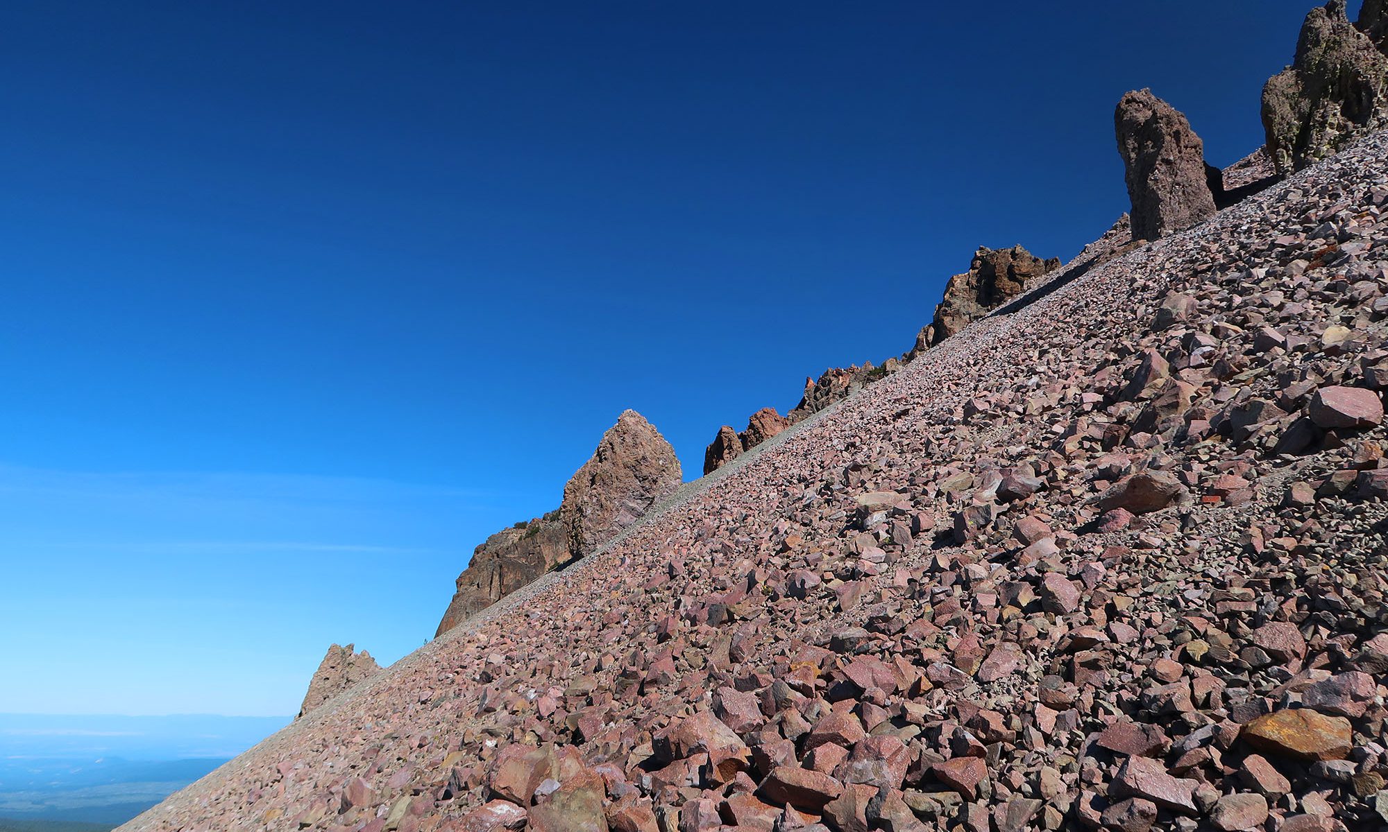
Lassen’s middle reaches were covered in an almost uniform layer of broken rocks, with some monolithic forms rising into the sky. It seemed to resemble a giant, incline zen garden.


California’s Youngest Rock
Eventually, I gained the high ridgeline of the mountain. The trail mellowed out in pitch, and the summit came into view. While I had pushed above tree line long ago, beautiful alpine flowers still poked out of the rock-work here and there.

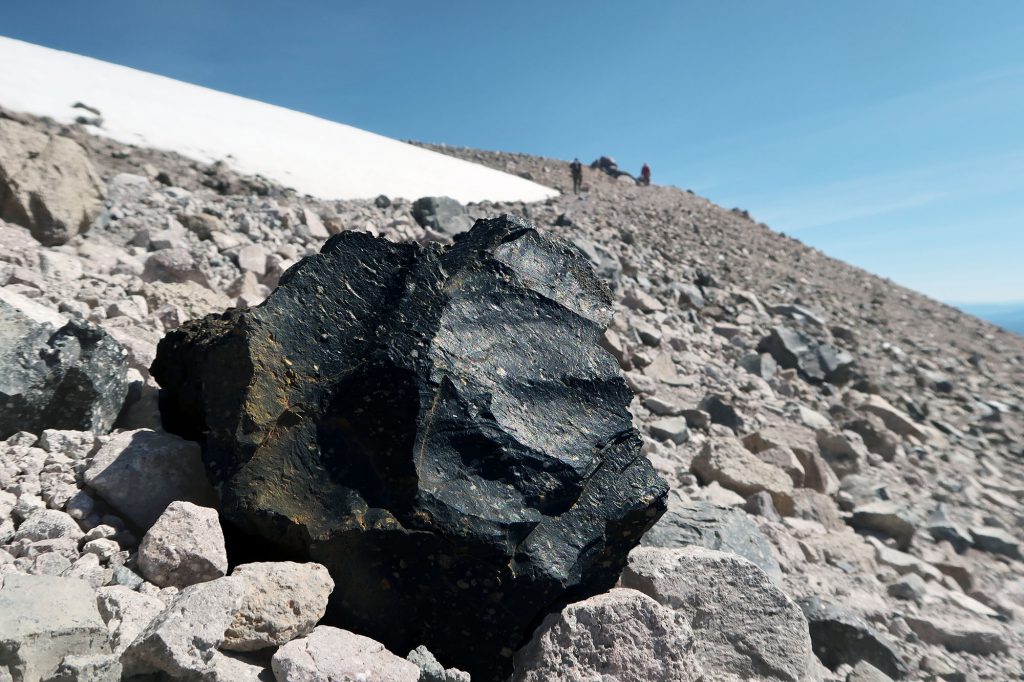
Interpretive signage along the trail informed me that the smooth, black boulders along the route were in fact “California’s youngest rock!” Lassen Peak underwent a few years of relatively violent eruptions between 1914-1917. The events blew open a crater on the summit and created violent “lahars” of melted snow, ice and mud flowing down into the valleys around the peak. These eruptions would remain the largest volcanic events in the Cascades until 1980. In that year, Mt St Helen would eject an entire Lassen-Peak-sized mass of material from its summit, in an event that would dwarf any other in post-Columbian North America.
Moments later, the trail terminated along the summit crater. Here I saw hikers resting and refueling while skiers strapped in for their descent. Between the craggy rocks of the crater, to the north, Mt Shasta rose high above the mountainous landscape.


Descent
After soaking in the summit views, I began a pleasant, uneventful descent back to the car park. I saw a few skiers make their way down the waning snowfields of Lassen’s wide bowls. Chipmunks zipped about the trail. Smiling hikers ascended past me. It was a lovely day for recreating in the mountains!

